Home


Indian Territory


  • Main Page
  • Collections
  • People
  • Places
  • Events
  • Major Topics
  • Documents
  • Images
  • Bibliography
  • Users Guide
  • Search
  • Site Navagation
  • About the Project
  • What is Anniversary Edition?
  • Credits
  • Dedication
  • Contact Us
  • Almanacs
    • 1857
    • 1858
    • 1859
    • 1860
    • 1861
    • 1862
    • 1863
    • 1864
    • 1865
    • 1866
    • 1867
  • Teachers Guide
    • Project Index
    • Blog Divided
    • Journal Divided
    • L-D Debates Digital Classroom
    • Digital Lincoln
    • UGRR Digital Classroom
    • Video Channel
    • Texas Farmer's Civil War

Kansas, 1857, zoomable map
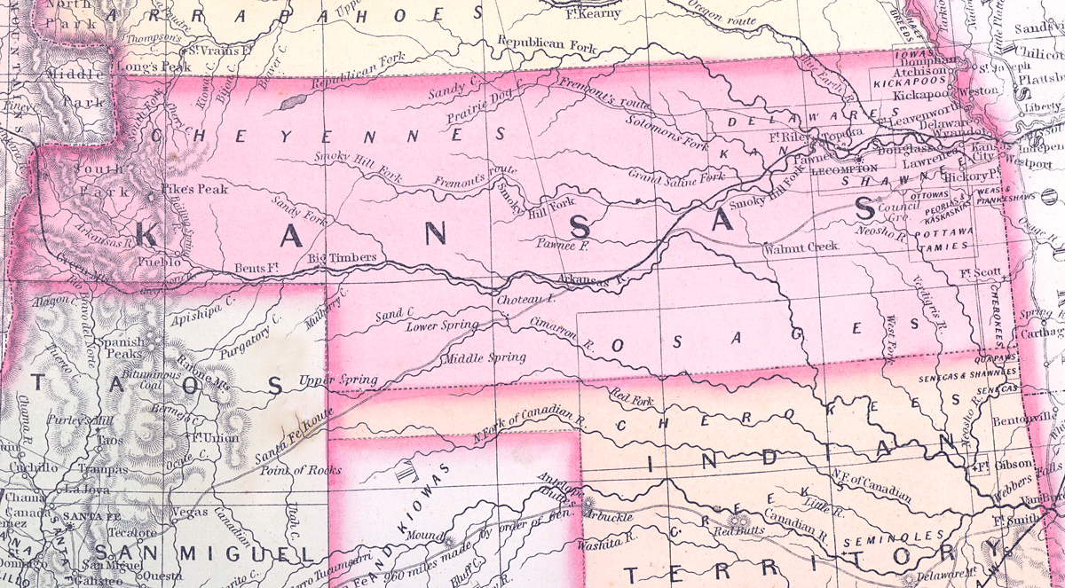
    Record Data
    Place Unit Type
    State or Province
    Containing Unit
    United States of America
    Events
    Date Type
    07/17/1863 In Indian Territory, Native American and African-American troops attack overrun Confederate supply base Battles/Soldiers
    07/14/1865 In Indian Territory, the Chickasaw Nation becomes the last Confederate entity formally to surrender Battles/Soldiers
    12/09/1861 In Indian Territory, Union and Confederate Native American troops clash at the Battle of Chusto-Talasah Battles/Soldiers
    People
    Places
    Name Type
    Tahlequah, IT City or Town
    Documents
    Date Title
    07/20/1863 James G. Blunt to Frank J. Bramhall, July 20, 1863
    Images

    Kansas, Nebraska, and Colorado, 1861, zoomable map

    Kansas, Nebraska, and Colorado, 1861, zoomable map

    How to Cite This Page: "Indian Territory," House Divided: The Civil War Research Engine at Dickinson College, https://hddev.housedivided.dickinson.edu/node/38167.

      creative commons logo 2007 - 2025

    sfy39587stp18